Difference between revisions of "ChartView"
| Line 8: | Line 8: | ||
*Airport Diagrams | *Airport Diagrams | ||
*NOTAMs | *NOTAMs | ||
| + | |||
| + | NOTE: Only NOTAM data for the selected airport is shown (when available). There may be other NOTAMs available pertaining to the flight that may not be displayed. Contact Jeppesen for more information regarding Jeppesen database-published NOTAMs. | ||
ChartView database is revised every 14 days. Charts are still viewable during a period that extends from the cycle expiration date to the disable date. ChartView is disabled 70 days after the expiration date and is no longer available for viewing but when turning on the system, the Power-up Page displays the current status of the ChartView database. | ChartView database is revised every 14 days. Charts are still viewable during a period that extends from the cycle expiration date to the disable date. ChartView is disabled 70 days after the expiration date and is no longer available for viewing but when turning on the system, the Power-up Page displays the current status of the ChartView database. | ||
Revision as of 20:30, 26 May 2015
ChartView resembles the paper version of Jeppesen terminal procedure charts for Garmin aviation products including the aera 510/560, GPSMAP 695/696 and aera 795/796, GTN series, G500/G600, G1000, G2000, G3000 and G5000 systems. The MFD depiction displays the aircraft position on the moving map in the plan view of the approach charts and on airport diagrams.
The ChartView database subscription is available from Jeppesen, Inc. Available data includes:
- Arrivals (STAR)
- Departure Procedures (DP)
- Approaches
- Airport Diagrams
- NOTAMs
NOTE: Only NOTAM data for the selected airport is shown (when available). There may be other NOTAMs available pertaining to the flight that may not be displayed. Contact Jeppesen for more information regarding Jeppesen database-published NOTAMs.
ChartView database is revised every 14 days. Charts are still viewable during a period that extends from the cycle expiration date to the disable date. ChartView is disabled 70 days after the expiration date and is no longer available for viewing but when turning on the system, the Power-up Page displays the current status of the ChartView database.
The geo-referenced aircraft position is indicated by an aircraft symbol displayed on the chart when the current position is within the boundaries of the chart. Inset boxes are not considered within the chart boundaries. Therefore, when the aircraft symbol reaches a chart boundary line, or inset box, the aircraft symbol is removed from the display.
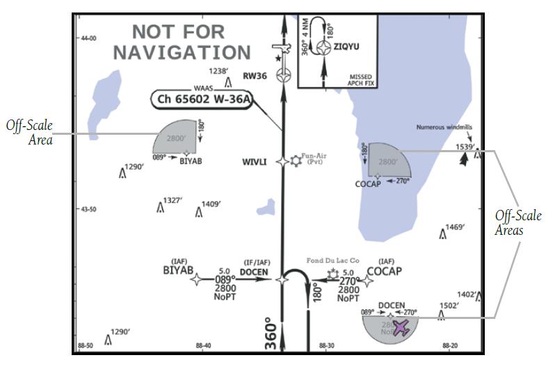
The figure below, shows examples of off-scale areas, indicated by the grey shading.
Note, the grey shading is for illustrative purposes only and will not appear on the published chart or display. These off-scale areas appear on the chart to convey supplemental information. However, the depicted geographical position of this information, as it relates to the chart planview, is not the actual geographic position. Therefore, when the aircraft symbol appears within one of these areas, the aircraft position indicated is relative to the chart planview, not to the off-scale area.