Difference between revisions of "SafeTaxi"
| Line 1: | Line 1: | ||
| − | [[Image:safetaxi_g3x.jpg|thumb|highslide=1:SafeTaxi | + | [[Image:safetaxi_g3x.jpg|thumb|highslide=1:SafeTaxi Diagram]] |
[[Image:safetaxi_gpsmap.jpg|thumb|highslide=1:SafeTaxi for GPSMAP 695/696]] | [[Image:safetaxi_gpsmap.jpg|thumb|highslide=1:SafeTaxi for GPSMAP 695/696]] | ||
[[Image:safetaxi_g1000.png|thumb|highslide=1:SafeTaxi for G1000]] | [[Image:safetaxi_g1000.png|thumb|highslide=1:SafeTaxi for G1000]] | ||
Revision as of 16:47, 26 May 2015


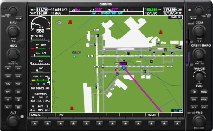
SafeTaxi® is the feature (software with airport diagrams database) for Garmin navigation systems that identifies runways, taxiways, FBOs, and hangars, as well as your aircraft's exact location on the field. SafeTaxi is seamlessly integrated with existing basemap data, so the airport information automatically appears at the appropriate map range setting — with details increasing as the range setting decreases. Since SafeTaxi is geo-referenced, pilots will benefit by seeing their aircraft icon move precisely along the taxiway diagram on their navigation screen. SafeTaxi includes position information for hundreds of airports, and updates are available every 56 days. SafeTaxi is integrated with the existing basemap data and the airport information is automatically appearing.
SafeTaxi is geo referenced, so that you can see your aircraft icon move across the navigation screen.
Check out the coverage offered by Garmin for:
SafeTaxi is available for a number of Garmin products, including the aera 510/560, GPSMAP 695/696 and aera 795/796, GTN series, G500/G600, G1000, G2000, G3000 and G5000 systems.