Difference between revisions of "GPSMAP 695"
| Line 9: | Line 9: | ||
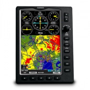
[[File:GPSMAP695.jpg|right|thumb|GPSMAP 695 Front View|link=]] | [[File:GPSMAP695.jpg|right|thumb|GPSMAP 695 Front View|link=]] | ||
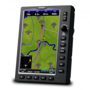
[[File:GPSMAP695a.jpg|right|thumb|GPSMAP 695 Front Overview|link=]] | [[File:GPSMAP695a.jpg|right|thumb|GPSMAP 695 Front Overview|link=]] | ||
| − | '''GPSMAP 695''' is a model designation of portable GPS receivers. | + | '''GPSMAP 695''' is a model designation of portable aviation GPS receivers with multi-functional display for navigation and mapping. |
'''Original Manufacturer:''' GARMIN (USA) | '''Original Manufacturer:''' GARMIN (USA) | ||
| Line 19: | Line 19: | ||
'''[http://en.wikipedia.org/wiki/ATA_100 ATA 100/JACS Code]:''' 34-45 | '''[http://en.wikipedia.org/wiki/ATA_100 ATA 100/JACS Code]:''' 34-45 | ||
| − | '''[http://www.usitc.gov/tata/hts/index.htm HTS Code:]''' 8526 91 0010, 8526 91 8010 | + | '''[http://www.usitc.gov/tata/hts/index.htm HTS Code:]''' 8526 91 0010, 8526 91 8010 |
► Click [http://www.acss.com/wp-content/uploads/TCAS-2000.pdf here] to download official OEM's datasheet. | ► Click [http://www.acss.com/wp-content/uploads/TCAS-2000.pdf here] to download official OEM's datasheet. | ||
Revision as of 18:16, 25 May 2015
  GPSMAP 695 is a model designation of portable aviation GPS receivers with multi-functional display for navigation and mapping. Original Manufacturer: GARMIN (USA) Status: in production (since 1997) Application: multiple ATA 100/JACS Code: 34-45 HTS Code: 8526 91 0010, 8526 91 8010 ► Click here to download official OEM's datasheet. Original Manufacturer: GARMIN Status: in production (since 2008)????????????? Application: ?????????? ATA 100/JACS Code: 25-62 ????????????? ContentsPart NumbersPart Number: 010-00667-50
Features► Large 7" diagonal WVGA sunlight readable display ► Battery: Replaceable, rechargeable Nickel-Metal Hydride ► Battery Life: Up to 2.5 hours battery life with full backlight and GXM 40 connected (8 hours with BL @ 50% and XM connected) ► 5 Hz High-sensitivity GPS receiver ► Flight Plans: 50 with up to 300 points each ► User waypoints: 3000 point active track ► Track log: 10,000 point active track ► Flight log: At least 50 most recent flights ► SD card slot for additional mapping data Bigger is better with Garmin's new GPSMAP-695. Its bright, sunlight readable, seven inch display is as crisp and color rich as any display available in a portable. This new larger format portable enables a full range of features not possible on smaller units, including: split screen panel page with full map, a high resolution terrain page with high contrast 2D depiction along with a vertical profile of terrain along your route of flight, and so much more. The GPSMAP 695 also becomes Garmin's first portable with Victor airways and Jet routes. The GPSMAP 695 also takes our intuitive, easy-to-use operations to a new level with an innovative rotary knob/joystick or "click stick". This G1000-like addition eliminates rocker pad data entry by providing a much faster rotary knob which selects alpha-numerics and advances the cursor with a quick tap of the joystick. The same joystick makes map panning and waypoint identification on the map page lightning fast. SpecificationsDisplay: Display size: 3.6"W x 6.0"H (9.1 x 15.2 cm); 7.0" diag (17.78 cm) Display resolution, WxH: 480 x 800 pixels Display type: bright, color WVGA TFT with adjustable backlighting Mechanical: Weight 35.7 ounces (1012 g) with battery pack; 22.4 ounces (635 g) without battery pack; 12.7 ounces (361 g) RAM mount Size: 144W x 196H x 51 D mm (5.7W x 7.7H x 2.0 D inches) Battery: rechargeable, replaceable Nickel-Metal Hydride Battery life: up to 3 hours with full backlight Water rating: No SBAS/WAAS receiver: high-sensitivity with WAAS position accuracy Environmental:
ApprovalInstallationOperationMaintenanceOTHERGarmin FliteCharts ® offer NACO-format IFR approach plates and terminal procedures for airports throughout the U.S. • Garmin SafeTaxi ® data provides detailed taxiway diagrams and position information for over 900 U.S. airports. • Color-keyed terrain page offers both overhead and vertical profile views of potentially hazardous terrain along your route of flight. • AOPA Airport Directory data offers detailed information on over 5,300 U.S. airports, along with airports of entry for Canada, Mexico and the Caribbean. Includes names and phone numbers of FBOs and fuel/service facilities, plus ground transportation, ATC data, and more. • IFR map mode displays Victor airways and Jet routes, derived from the navigation database. • Traffic Information Service (TIS) alerts (where available) are supported via Garmin GTX 330 Mode S Transponder interface. • Supports XM satellite weather data and audio entertainment 1 (GPSMAP 696 only) • Garmin’s Smart Airspace ™ feature aids visual clarity on - screen – by de-emphasizing airspace that’s well above or below the aircraft’s current altitude. • Fast 5 Hz GPS update speed gives a smoother, near “real-time” presentation of flight data for added realism and safety. • To help keep pilots aware of special airspace activity, over 650 parachute drop zones are detailed in the Americas navigation database. https://buy.garmin.com/en-US/US/in-the-air/portable-gps/gpsmap-695/prod14860.html http://support.garmin.com/support/manuals/manuals.htm?partNo=010-00667-50&language=en&country=US краткое описание на русском Click here краткое описание на русском Click here to view official OEM's brochure # M02-10185-00. Также в интернете можно найти статьи на русском |