Difference between revisions of "AERA 500"
(→aeroscan) |
|||
| (79 intermediate revisions by 2 users not shown) | |||
| Line 6: | Line 6: | ||
|style="background-color:#F3F3F3; border:1px solid #A7D7F9;"|[[:ru:AERA 500|RU]] | |style="background-color:#F3F3F3; border:1px solid #A7D7F9;"|[[:ru:AERA 500|RU]] | ||
|} | |} | ||
| − | [[Image: | + | [[Image:aera_500_front.png|200px|thumb|highslide=1:aera 500 - Front View]] |
| − | '''AERA 500 (aera® 500)''' is a model designation of portable aviation GPS receivers with | + | [[Image:aera_500_back.png|200px|thumb|highslide=1:aera 500 - Back View]] |
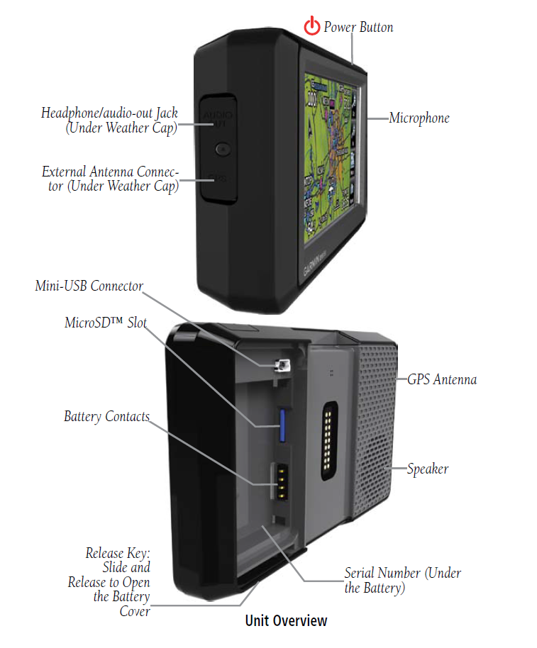
| + | [[Image:aera_500_uov.png|200px|thumb|highslide=1:aera 500 - Unit Overview]] | ||
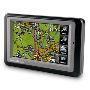
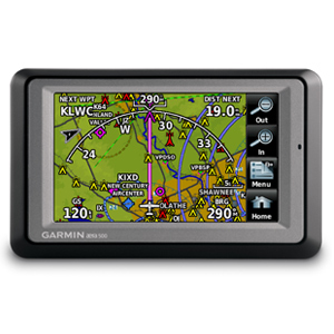
| + | '''AERA 500 (aera® 500)''' is a model designation of portable aviation GPS receivers with touchscreen display and automotive navigation mode. | ||
'''Original Manufacturer:''' GARMIN (USA) | '''Original Manufacturer:''' GARMIN (USA) | ||
| − | '''Status:''' <span style="color:green">in production</span> (since | + | '''Status:''' <span style="color:green">in production</span> (since 2009) |
'''Application:''' multiple | '''Application:''' multiple | ||
| Line 19: | Line 21: | ||
'''[http://www.usitc.gov/tata/hts/index.htm HTS Code:]''' 8526 91 2099, 8526 91 2010 | '''[http://www.usitc.gov/tata/hts/index.htm HTS Code:]''' 8526 91 2099, 8526 91 2010 | ||
| − | ► Click [ | + | ► Click [https://static.garmincdn.com//pdfs/specs/aera_spec.pdf here] to view official OEM's brochure No. M02-10196-00. |
==Part Numbers== | ==Part Numbers== | ||
{| class="wikitable" | {| class="wikitable" | ||
| − | + | |- | |
|'''Kit P/N''' | |'''Kit P/N''' | ||
|'''Description''' | |'''Description''' | ||
|- | |- | ||
| − | |[[010- | + | |[[010-00836-00]] |
| − | | | + | |aera 500 with Americas Navigation Data, US Obstacles |
|- | |- | ||
| − | |[[010- | + | |[[010-00836-01]] |
| − | | | + | |aera 500 with Atlantic Navigation Data w/ VFR reporting points (VRPs), Europe Obstacles |
|- | |- | ||
| − | |[[010- | + | |[[010-00836-02]] |
| − | + | |aera 500 with Pacific Navigation Data w/ VFR reporting points (VRPs) | |
| − | + | |} | |
| − | + | ||
| − | |Pacific Navigation Data w/ VFR reporting points (VRPs) | + | |
| − | + | ||
| − | + | ||
All units goes with Worldwide Basemap and Worldwide Terrain. | All units goes with Worldwide Basemap and Worldwide Terrain. | ||
| + | |||
==Features== | ==Features== | ||
| − | * | + | *Preloaded world Basemap and world Terrain database |
| − | * | + | *Ability to add maps |
| − | * | + | *Accepts microSD™ data cards |
| − | * | + | *Ability to add additional points of interest (POI) |
| − | + | *Waypoints/favorites/locations: 3,000 (aviation mode); 1,000 (automotive mode) | |
| − | * | + | *Navigation database: Jeppesen® data (coverage areas: Americas or Atlantic or Pacific) |
| − | * | + | *Types of Jeppesen data: full and ARTCC, FSS frequencies and final approach waypoints |
| − | + | *Preloaded Obstacle database: U.S. and Europe only | |
| − | * | + | *Preloaded low & high altitude enroute airways |
| − | *Preloaded low & high altitude enroute airways | + | *Preloaded private airports: U.S. only |
| − | *Preloaded | + | *Moving map |
| − | * | + | *HSI (GPS-based) |
| − | * | + | *IFR and VFR map modes |
| − | *Audible terrain alerts | + | *Audible terrain alerts |
| − | * | + | *Smart Airspace Feature (generates and displays altitude-sensitive alerts) |
| − | *Separate serial and USB interfaces | + | *Automatic logbook |
| − | * | + | *Separate serial and USB interfaces |
| + | *GPS receiver has a nominal operating velocity range of 0 – 800 kts (411 m/s) | ||
| + | *Internal GPS updates at a rate of 5 times per second (5 Hz) | ||
| + | *Traffic Information Services ([[TIS]]) alerts compatible through Garmin Mode S transponder (e.g. [[GTX 330]]) | ||
*Capable to display ADS-B, [[TIS]]-B traffic and weather [[FIS]]-B information received from [[GDL 39]] receiver through a power/data cable | *Capable to display ADS-B, [[TIS]]-B traffic and weather [[FIS]]-B information received from [[GDL 39]] receiver through a power/data cable | ||
| − | * | + | *Ability to load communications frequencies into [[SL 40]] Comm or [[SL 30]] Nav/Comm transceiver |
| − | + | A database-driven terrain advisory feature offers TAWS-like color coding and pop-up alerts when possible obstructions or ground proximity conflicts loom. And with terrain/obstacle data shown at standard 30 arc-second resolution, you’ll enjoy a surprising level of detail on the display. Its graphical Terrain page offers both overhead and vertical profile views of the topography you’re flying over. IFR map mode lets you display and navigate on high or low enroute airways. You can also pull up MEAs (Minimum Enroute Altitudes) and distances between intersections by touching the airway on the map. | |
| − | + | ||
| − | + | ||
==In the Box== | ==In the Box== | ||
| − | * | + | *aera 500 unit with battery |
*Free single Jeppesen® Update Coupon ([[190-00248|190-00248-00]]) | *Free single Jeppesen® Update Coupon ([[190-00248|190-00248-00]]) | ||
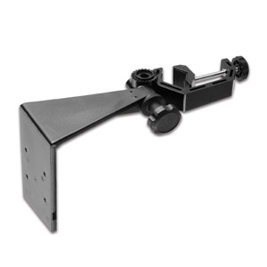
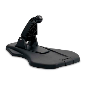
| − | *Yoke | + | *Yoke Mount ([https://buy.garmin.com/en-US/US/shop-by-accessories/mounts/yoke-mount-bracket-only-/prod51122_010-11385-00.html 010-11385-00]) with bracket and power cable |
| − | + | *Portable Friction Mount with Bracket Mount P/N [https://buy.garmin.com/en-US/US/shop-by-accessories/mounts/bracket-mount/prod66847_010-11455-00.html 010-11455-00] (011-02025-00) | |
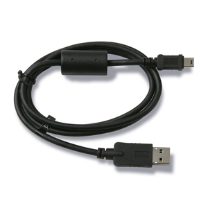
| − | + | *USB cable | |
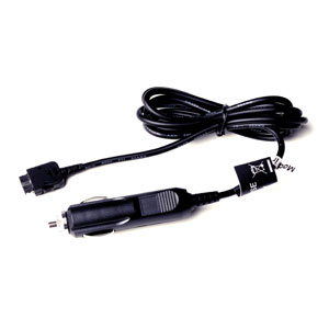
| − | * | + | *Vehicle power cable |
| − | + | *Pilot's guide and owner's manual | |
| − | + | ||
| − | + | ||
| − | * | + | |
| − | * | + | |
| − | * | + | |
{| class="wikitable" | {| class="wikitable" | ||
|- | |- | ||
| − | |[[Image: | + | |[[Image:aera_500.png|120px|highslide=1:aera 500 unit]] |
| − | |[[Image:010- | + | |[[Image:010-11143-00.png|120px|highslide=1:Battery]] |
|[[Image:190-00248-00.png|120px|highslide=1:Free single Jeppesen® Update Coupon]] | |[[Image:190-00248-00.png|120px|highslide=1:Free single Jeppesen® Update Coupon]] | ||
| − | |[[Image:010- | + | |[[Image:010-11385-00.png|120px|highslide=1:Yoke Mount]] |
| − | + | ||
|- | |- | ||
| − | |[[Image:010- | + | |[[Image:010-11455-00.jpg|120px|highslide=1:Bracket Mount]] |
| − | |[[Image:010- | + | |[[Image:010-11280-02.png|120px|highslide=1:Portable friction mount]] |
| − | |[[Image:010- | + | |[[Image:010-10723-15.png|120px|highslide=1:USB cable]] |
| − | + | |[[Image:010-10747-03.png|120px|highslide=1:Vehicle power cable]] | |
| − | |[[Image:010- | + | |
|} | |} | ||
==Accessories== | ==Accessories== | ||
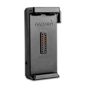
| − | [[Image:010- | + | [[Image:010-11385-03.png|150px|thumb|highslide=1:aera 5XX Aviation Mount (Bare Wires)]] |
| − | [[Image: | + | [[Image:PD16.png|150px|thumb|highslide=1:aera 5XX Panel Dock]] |
| − | *Yoke Mount P/N [https://buy.garmin.com/en-US/US/shop-by-accessories/mounts/ | + | *Yoke Mount P/N [https://buy.garmin.com/en-US/US/shop-by-accessories/mounts/yoke-mount-bracket-only-/prod51122_010-11385-00.html 010-11385-00] |
| − | + | *Panel Dock Mount from AirGizmos, P/N [http://www.airgizmos.com/assets/images/products/pd16/Aera_2sided-low.pdf PD16] | |
| − | *Panel Dock Mount from AirGizmos, P/N [http://www.airgizmos.com/ | + | *AC Adapter with International plugs, P/N 010-11385-05 |
| − | *AC | + | *Carrying Case, P/N [https://buy.garmin.com/en-US/US/shop-by-accessories/cases-and-covers/carrying-case/prod32726_010-11270-00.html 010-11270-00] |
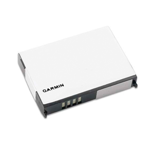
| − | * | + | *Lithium Ion battery pack (replacement), P/N [https://buy.garmin.com/en-US/US/shop-by-accessories/batteries/lithium-ion-battery-nuvi-/prod27338_010-11143-00.html 010-11143-00] |
| − | + | *aera® 5XX Aviation Mount (Bare Wires), P/N [https://buy.garmin.com/en-US/US/shop-by-accessories/mounts/aera-5xx-aviation-mount-bare-wires-/prod51125_010-11385-03.html 010-11385-03] | |
| − | * | + | *GA 25MCX Remote GPS Antenna (Low Profile), P/N [https://buy.garmin.com/en-US/US/shop-by-accessories/antennas/ga-25mcx-remote-gps-antenna-low-profile-/prod1326_010-10702-00.html 010-10702-00] |
| − | * | + | |
| − | + | ||
| − | + | ||
*Suction cup mount for GA 25 antenna P/N [[010-10871-00]] | *Suction cup mount for GA 25 antenna P/N [[010-10871-00]] | ||
| − | |||
==Specifications== | ==Specifications== | ||
| − | * | + | *Physical dimensions: 5.3"W x 3.3"H x 0.9"D (13.5 x 8.4 x 2.3 cm) |
| − | * | + | *Display size, WxH: 3.81"W x 2.25"H (9.7 x 5.7 cm); 4.3" diag (10.9 cm) |
| − | *Battery: | + | *Display resolution, WxH: 480 x 272 pixels |
| − | *Battery life: up to | + | *Display type: touchscreen WQVGA color TFT with white backlight |
| − | *Water | + | *Weight: 9.5 ounces (270 g) |
| + | *Battery: removable, rechargeable lithium-ion | ||
| + | *Battery life: up to 5 hours (less with full backlight and options) | ||
| + | *[[Water Rating]]: IPX7 | ||
*SBAS/WAAS receiver: high-sensitivity with WAAS position accuracy | *SBAS/WAAS receiver: high-sensitivity with WAAS position accuracy | ||
| − | * | + | *Input Power: 11-35 VDC |
| − | + | ||
| − | + | ||
| − | + | ||
==Approval== | ==Approval== | ||
| − | Click [http:// | + | Click [http://static.garmincdn.com/pumac/aera500_DeclarationofConformity.pdf here] to download Garmin's Declaration of Conformity. |
This device complies with part 15 of the [http://en.wikipedia.org/wiki/U.S._Federal_Communications_Commission FCC] Rules. Operation is subject to the following two conditions: | This device complies with part 15 of the [http://en.wikipedia.org/wiki/U.S._Federal_Communications_Commission FCC] Rules. Operation is subject to the following two conditions: | ||
| Line 134: | Line 123: | ||
==Installation== | ==Installation== | ||
| − | *Yoke | + | *Yoke Mount P/N 010-11385-00 used to mount the aera 500 on the plane's yoke. |
| − | + | ||
| − | + | ||
| − | *There are also available non-Garmin panel docks from AirGizmos, P/N [http://www.airgizmos.com/ | + | *There are also available non-Garmin panel docks from AirGizmos, P/N [http://www.airgizmos.com/assets/images/products/pd16/Aera_2sided-low.pdf PD16] |
==Operation== | ==Operation== | ||
<div id="1"></div> | <div id="1"></div> | ||
{|style="float:right;margin-left:10px; font-size:0.9em;margin-top:10px" | {|style="float:right;margin-left:10px; font-size:0.9em;margin-top:10px" | ||
| − | |{{#widget:YouTube|width=400|height=300|id= | + | |{{#widget:YouTube|width=400|height=300|id=jJVvd2pFEn8}} |
|- | |- | ||
| − | | | + | |Introduction of new aera |
|} | |} | ||
| − | *[http:// | + | *[http://static.garmincdn.com/pumac/190-01117-03_0B_Web.pdf Aviation Quick Reference Guide] Doc. No. [[190-01117-03]] |
| − | *[http:// | + | *[http://static.garmincdn.com/pumac/190-01117-02_0C_web.pdf Pilot's Guide ] Doc. No. [[190-01117-02]] |
| − | + | ||
| − | + | ||
==Maintenance== | ==Maintenance== | ||
| − | Maintenance of the | + | Maintenance of the aera 500 is ‘on condition’ only. |
This device can be repaired only at the Garmin factory or a Garmin authorized service center. This product does not contain any user-serviceable parts. Unauthorized repairs or modifications could result in permanent damage to the equipment, and void your warranty. | This device can be repaired only at the Garmin factory or a Garmin authorized service center. This product does not contain any user-serviceable parts. Unauthorized repairs or modifications could result in permanent damage to the equipment, and void your warranty. | ||
Latest revision as of 13:44, 2 September 2015
   AERA 500 (aera® 500) is a model designation of portable aviation GPS receivers with touchscreen display and automotive navigation mode. Original Manufacturer: GARMIN (USA) Status: in production (since 2009) Application: multiple ATA 100/JACS Code: 34-57 HTS Code: 8526 91 2099, 8526 91 2010 ► Click here to view official OEM's brochure No. M02-10196-00. ContentsPart Numbers
All units goes with Worldwide Basemap and Worldwide Terrain. Features
A database-driven terrain advisory feature offers TAWS-like color coding and pop-up alerts when possible obstructions or ground proximity conflicts loom. And with terrain/obstacle data shown at standard 30 arc-second resolution, you’ll enjoy a surprising level of detail on the display. Its graphical Terrain page offers both overhead and vertical profile views of the topography you’re flying over. IFR map mode lets you display and navigate on high or low enroute airways. You can also pull up MEAs (Minimum Enroute Altitudes) and distances between intersections by touching the airway on the map. In the Box
Accessories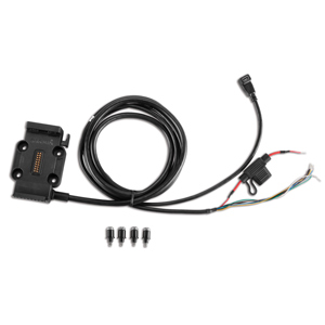 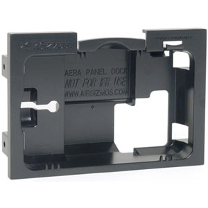
Specifications
ApprovalClick here to download Garmin's Declaration of Conformity. This device complies with part 15 of the FCC Rules. Operation is subject to the following two conditions:
This equipment has been tested and found to comply with the limits for a Class B digital device, pursuant to part 15 of the FCC rules. These limits are designed to provide reasonable protection against harmful interference in a residential installation. This equipment generates, uses, and can radiate radio frequency energy and may cause harmful interference to radio communications if not installed and used in accordance with the instructions. However, there is no guarantee that interference will not occur in a particular installation. Installation
Operation
MaintenanceMaintenance of the aera 500 is ‘on condition’ only. This device can be repaired only at the Garmin factory or a Garmin authorized service center. This product does not contain any user-serviceable parts. Unauthorized repairs or modifications could result in permanent damage to the equipment, and void your warranty. |